Tag Archives: Exploration

Earliest photographic views of venezuela, 1857

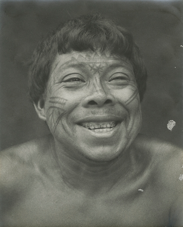
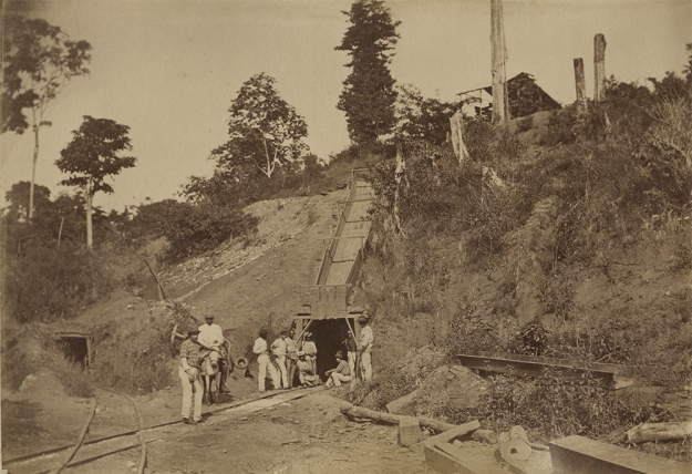
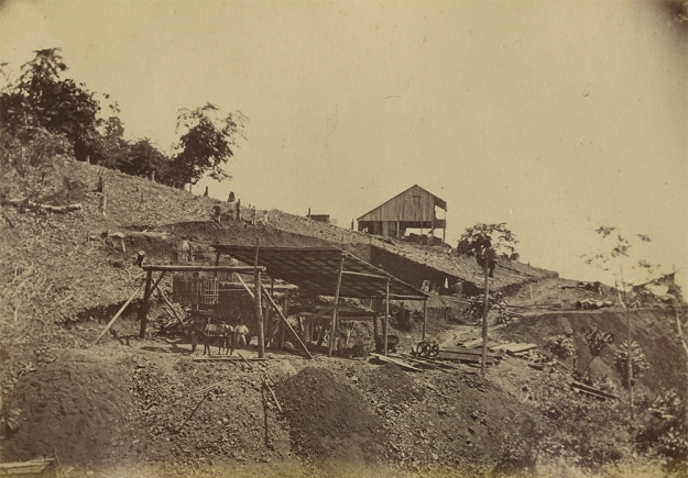
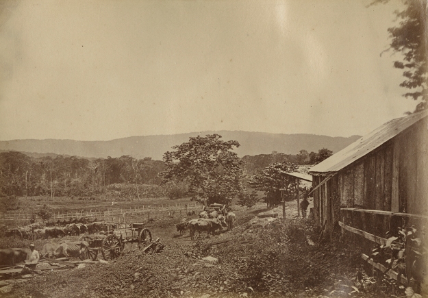
Pal Rosti Barkoczi (also known as Paul de Rosti) was a pioneer of photography in Venezuela. The eleven views of Caracas and the valle the Aragua he left us are the earliest photographic views of Venezuela – and should be ranked as masterpieces of primitive photography.

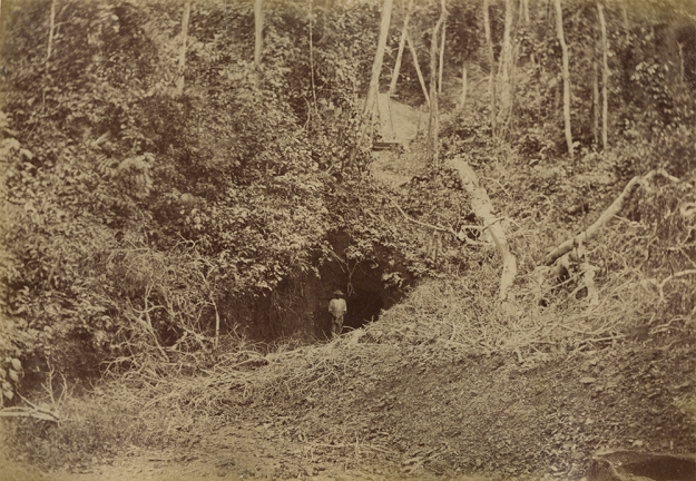
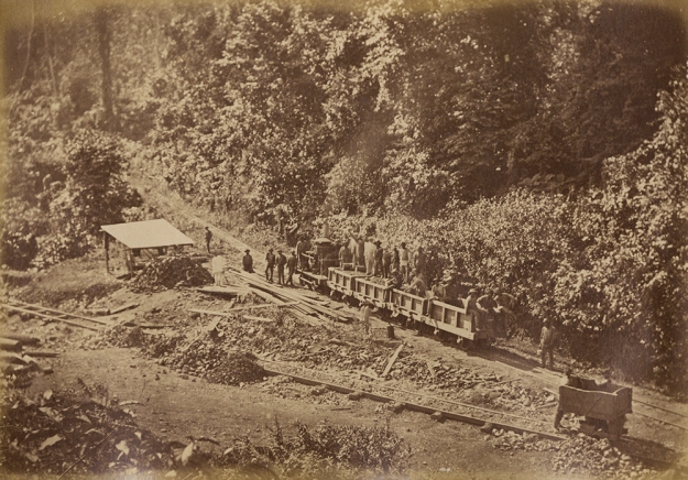
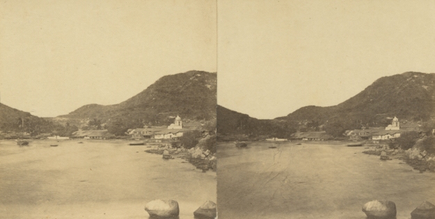
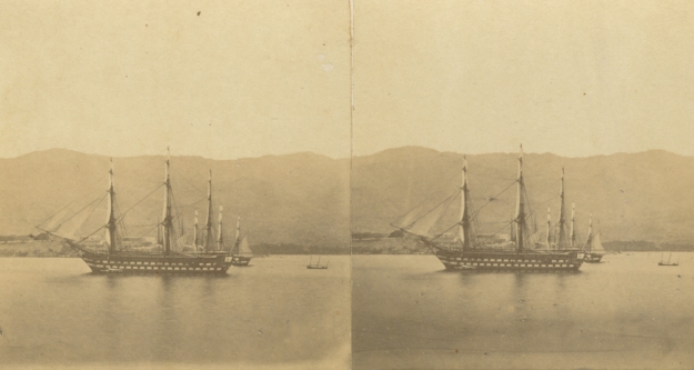
Quebrada de Catuche (all titles are the original from Rosti hand)

Pal Rosti was born in Budapest, Hungary, in 1830. He studied at the university of Munich School of Science for four years then geography and ethnography in Budapest in 1853. In 1854 and 1855, Rosti is probably in Paris, learning photography. Although he doesn’t appear in the extensive list of Gustave Le Gray students, he certainly learnt his waxed paper negative process.

La Trinidad et le grand Samang

On August 4th 1856 he embarks from le Havre to New York, and travels in the United States as far as Wisconsin. In January 1857 he arrives in Cuba.

He lands in Venezuela probably late March 1857, arriving in La Guaira (he leaves Cuba on March 12th and sails thru Saint-Thomas) and leaves Venezuela at the end of June. So he spends at most three months travelling from la Guaira to Angostura.

His trip in Venezuela includes visit to Caracas, the Valle de Aragua (San Mateo and the El Palmar hacienda) then south to San Juan del Moros, probably the Lllanos, then the Orinoco river up to Angostura (now Ciudad Bolivar). But he photographs only Caracas and the Valle de Aragua. A quote from his diary explains why : “In order to simplify my trip, I left my cameras at “El Palmar” which I wouldn’t have been able to use anyway in the Llanos, and my extra luggage as well, requesting them to send it on to Saint Thomas from La Guaira. I found them there after several months.”

From Angostura he probably sails back to Saint-Thomas and then to Veracruz, Mexico.

El grande Samang, cerca de Turmero, valle de Aragua

Rosti lands on 8 August 1858 in Southampton. From there, it is very likely that he travels to Paris, then Hungary thru Berlin. On November 1st 1858, Rosti visits Alexander Von Humboldt, the inspiration for his travel,  in his house in Berlin and offers him an album of forty seven photographic views (the copy presently at the Ludwig Museum in Cologne). At the beginning of 1859, he exhibits his photographic views of Cuba, Venezuela and Mexico at the National Casino in Budapest.

La Pastora

The bindings of all four existing album bear the mark of Despierres from Paris. We therefore know that all prints were made between his arrival in Southampton and his arrival in Berlin. It is more than likely that the prints were also made in Paris – the Le Gray atelier a prime suspect for such a wonderful job. We also know that Rosti had less than three months, between his arrival in England and his meeting with Humboldt, to have the photographs printed and the album bound – including travel time from Southampton to Berlin via Paris. That might explain why so few copies of the album are known.

Hacienda de azucar, près de Caracas
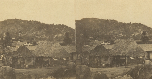
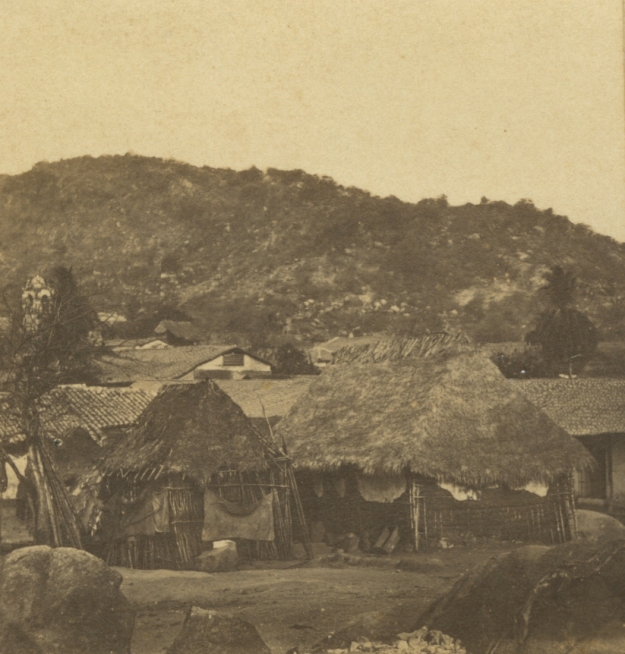
San Mateo

Four albums are known, three of which are located in Hungary and one in Germany. The contents of the three albums located in Hungary are not identical. The copy in the National Széchenyi Library which was originally given to the Hungarian National Museum contains 45 prints, the album in the Museum of Photography contains 47 prints, the album of the Loránd Eötvös Geophysical Institute contains 40 prints. The album in Cologne contained 47 prints (with 5 missing today).

In the two 47 prints albums, four pictures show parts of Havana, 11 photograph landscapes and buildings in Venezuela, and the remaining 32 from Mexico.

La maison de Bolivar

Une plantation de café

San Juan de los Moros

The whereabouts of the paper negatives are unknown. None of the photographs he might have taken in France or the United States have ever been found.

I am very grateful to the Ludwig Museum in Cologne for letting me have a long look at this stunning album.

YOU CAN ALSO FOLLOW US ON INSTAGRAM : GREGORYLEROYPHOTO

DiGiovanni – Beer Expedition (1938-1940)

Indio Guahibo, Tuparro (Vichada)

Indio Guahibo, Tuparro (Vichada)

Indios Guajiros, Manaure - Guajira

Indios Guajiros, Manaure – Guajira

Loza de Indios Piapocos - Vichada

Loza de Indios Piapocos – Vichada.

Durante la última década hemos coleccionado más de 50 fotografías poco comunes de Paul Beer hechas en sus viajes a la Orinoquia colombiana entre 1938 y 1940.

Beer fue un fotógrafo alemán que emigró a Colombia en 1928, donde desarrolló todo un trabajo fotográfico muy importante para la cultura colombiana y donde vivió hasta su muerte en 1979.

Su trabajo e interés por la fotografía documental lo hacen un testigo excepcional del siglo XX en estas tierras. Con su obra fotográfica logró registrar dos momentos extraordinarios muy representativos de la historia de Colombia: por un lado, una mirada al mundo indígena casi en las condiciones de un viaje al pasado, retrocediendo siglos en el tiempo; y por el otro, una mirada al futuro con su obra más conocida que representa las grandes transformaciones de la arquitectura y la ciudad de la modernización. Beer dejó un enorme legado de más de 9000 negativos de los cuales 2000 de ellos son de sus expediciones a la Orinoquia y Amazonia.

Vegetación tropical - Río Imírida.

Vegetación tropical – Río Imírida.

Famille d’indiens devant une hutte, 1938.

Familia de indígenas delante una choza, 1938. 

An indian warrior in front of his hut, 1938.

Un guerrero indígena delante su choza, 1938.

Indio Piapoco en cacería. Río Cadá - Vichada.

Indio Piapoco en cacería. Río Cadá – Vichada.

Su trabajo con los indígenas es bastante desconocido y ha sido en los últimos años cuando se ha empezado a publicar. Las fotografías en este post fueron tomadas en dos viajes realizados a la Orinoquia y Amazonia colombianas entre 1938 y 1942 aproximadamente. Son imágenes de registros detallistas sobre la vida diaria de comunidades indígenas de los hoy departamentos del Vichada, Guainía, Guaviare, Meta y Vaupés. En este último vivió durante al menos dos años en una comunidad Guahiba.

Para dar contexto al viaje de Beer a la Orinoquia y Amazonia debemos tomar en cuenta la participación de Felix V. DiGiovanni, un norteamericano de origen italiano que llegó al país a mediados de la década del treinta. Se piensa que fue él el que organizó la expedición, invitando a Beer, quien pudo ver el viaje como una oportunidad única de conocer el país inexplorado.

Existe un registro más preciso sobre el primer viaje a la Orinoquia, compuesto por la gran mayoría de fotografías etnográficas, un manuscrito descriptivo de Giovanni titulado “The Call of the Curassow and the Land of the Guahibo Indians” e incluso un mapa con la ruta del viaje dibujada por Beer. Se trataba entonces de dos viajeros, buscando suerte en un país extraño y con la firme decisión de conocerlo mejor que los propios colombianos. Todavía existen muchos interrogantes sobre la naturaleza del viaje, pues duró al menos dos o tres años, para el cual debió haber una cierta logística y financiación. Como se puede ver en algunas fotos de registro de la expedición, se trataba de un grupo de personas coordinadas, guías, interpretes, cargadores y un peso considerable de equipos de fotografía, negativos, provisiones y productos para intercambiar con las comunidades.

DiGiovanni no formó parte del segundo viaje.

Indio Guahibo, cogiendo raya en un barbasquero - Vichada

Indio Guahibo, cogiendo raya en un barbasquero – Vichada

Navegación en el Río Vaupés.

Navegación en el Río Vaupés.

De las fotografías de estas expediciones vale la pena destacar las series completas hechas a partir de un seguimiento detallado de las actividades de la vida diaria de los indígenas. Hay registros sobre la construcción de una maloca, la preparación de la yuca brava, escenas de caza y pesca, elaboración de vasijas, pintura facial, ceremonias indígenas, etc. También podemos encontrar una serie de retratos muy naturales de los indígenas en su entorno natural y documentación del registro del viaje como fueron las dificultades del terreno, una canoa atascada en unos rápidos de uno de los ríos y retratos de los viajeros con su equipo.

Indios Guahibos, haciendo casa - Vichada

Indios Guahibos, haciendo casa – Vichada

Según la ruta que podemos ver pareciera que parte del viaje consistió en tratar de contactar una comunidad en las mayores condiciones de aislamiento posible para poder registrar un grupo virgen, no contaminado por la civilización occidental.

Este trabajo es en realidad un completo y detallado estudio etnográfico visual sobre viarias comunidades de los indígenas de los Llanos Orientales de Colombia.

Luego de estas expediciones Beer nunca volvió a retratar personas sino que se enfocó en la fotografía arquitectónica, su trabajo más conocido.

Pueblo de Indios Puinabos - Río Guaviare

Pueblo de Indios Puinabos – Río Guaviare

Indios Guananos - Río Vaupés

Indios Guananos – Río Vaupés

Indio Guahibo tomando moñoco - Vichada

Indio Guahibo tomando moñoco – Vichada

Una de las preguntas más importantes que tenemos sobre Beer es: ¿por qué tantas de estás imágenes han aparecido en París?


Literatura consultada: Paul Beer, Luis Carlos Colón, Santiago Rueda, and Juan Pablo Fajardo. Paul Beer. Bogotá, Colombia: La Silueta Ediciones, 2009. Print.

Paul Beer, 1936

Indio Motilone, Río de Oro, Colombia, 1936.

Indio Motilone, Río de Oro, Colombia, 1936.

We finally get a chance to post about Colombia…

We just acquired in Paris an unusual Paul Beer photograph. A hand-coloured gelatin silver print, it is signed, and dated “1936”.

We have been building for the last four years an important collection of Paul Beer’s ethnographic photographs, all of them dated from 1938 to 1939. The DiGiovanni-Beer expedition of 1937-1938 in the Colombian Amazonia and along the Orinoco river is well documented, and reproduced extensively in the few books about his work (notably in Paul Beer, la Silueta ediciones, Bogota, 2009). Beer made a second trip to the Amazon thought to be around 1940-1942, without DiGiovanni and with less resources; however, there are no dated documents to corroborate the exact dates of this exhibition. To our knowledge few images prior to 1938 are known…

Paul Beer arrived in Colombia in 1928. Little is known about is life and works until 1938.

The Rio de Oro, a tributary of the Catatumbo, runs in North-eastern Colombia, close to the Venezuelan border. The Motilone people, also know as Bari, inhabit the Catatumbo basin on both sides of the border. There is no mention of a trip to that area of Colombia by Paul Beer.

This photograph of the Motilone indian is very important when looking at Beer’s photographic work not only because of the date but because most of his ethnological work consisted on documenting the life of the Guahibo indians; taking portraits of them and photographing their customs, houses, and landscapes of the region (including the flora and rivers).

Paul Beer - Indio Guahibo, Tuparro (Vichada)

Indio Guahibo, Tuparro (Vichada), c. 1939.

Paul Beer - Indio Guahibo tomando moñoco - Vichada, c. 1939.

Indio Guahibo tomando moñoco – Vichada, c. 1939.

The Search for Gold in Venezuela – 1875

The following images were taken in 1875 in the mining town of El Callao, Venezuela, then known as Caratal.

Minas del Callao y Caratal, Estado Bolívar, Venezuela. Siglo XIX.

Entrée de la mine. / The entrance to the mine.

We are not surprised by the fact that these photographs surfaced in France since one of the biggest mining companies in the area, Compañía Minera Nacional Anónima El Callao, was created by the Corsican traders Antonio Liccioni and Jean Cagninacci in 1870.

El Callao is a town in the Venezuelan Guiana Highlands. It has been a gold-mining centre since it was founded in 1853; however, it is said that mining in Caratal started as early as 1824 by the indigenous population in this area. The gold rush of 1853 attracted gold-hunting adventurers from England, America, France and the Caribbean islands when it was discovered that these mines contained 1.5 kilograms of gold per ton, when the best gold mines in other parts of the world had only 120 grams of gold per ton.

By 1885 El Callao had become the world’s leading producer of gold – having produced 8.193,510 Kgr of gold that year.

The first gold rush was over by 1899, and the mines were for long thought to be exhausted, but a combination of new technology and high gold prices in the 1970s led to the redevelopment of the mines by CVG (Corporación Venezolana de Guayana) Minerven, a Venezuelan national mining corporation. Since 2009, the gold-mining industry in Venezuela has been steadily deteriorating as production levels continue to fall.

Over the years several explorers and writers have proposed that the area that comprises the mines in El Callao and others mines around it might have been the real mythical city of gold, “El Dorado.”

The photographer is still unknown.

Minas del Callao y Caratal, Estado Bolívar, Venezuela. Siglo XIX.

Mine d’or au Caratal (Venezuela), 1875. / Gold mine in Caratal (Venezuela), 1875.

Minas del Callao y Caratal, Estado Bolívar, Venezuela. Siglo XIX.

Mine d’or du Caratal (Venezuela) / Gold mine of Caratal (Venezuela)

Minas del Callao y Caratal, Estado Bolívar, Venezuela. Siglo XIX.

De Las Tablas à Guasipati – Route pour se rendre aux Mines d’or de l’Yuruari. / From Las Tablas to Guasipati – Road to get to the gold mines of Yuruari.

Minas del Callao y Caratal, Estado Bolívar, Venezuela. Siglo XIX.

Forêt vierge – Guyanne Vénézuelienne, 1875. / Virgin forest – Venezuelan Guiana, 1875.

Minas del Callao y Caratal, Estado Bolívar, Venezuela. Siglo XIX.

Tramway pour transport des quartz du bois. Mine d’or du Caratal. / Tramway to transport quarts from the forest. Gold mind of Caratal.

Early images of Acapulco.

In April 2013, ethnologist Samuel Villela Flores presented his investigation about Acapulco during the seminar
 “De la Villa de Acapulco al Acapulco del Jet set. 160 años de fotografía en el Puerto” that took place at the Coordinación Nacional de Antropología in Mexico City.

In his findings Villela states that Acapulco has been photographed since the mid XIX century by daguerreotypists and travelers. The first known daguerreotypes of Acapulco were made by Robert H. Vance circa 1850.

Two of these daguerreotypes (‘Panoramic View of Acapulco, from a hill back of the city, showing the City, Fort, Harbor, with the Steamers, Panama and 
Sea Bird, and others, lying at anchor’ and ‘Acapulco, from the Bay, show a front view of the city and
mountains in the back ground.’[1]) were exhibited in “Views in California” a show presented at No. 349 Broadway, (opposite the Carleton House,) in New York, in October of 1851. However, neither are known to have survived this legendary exhibition.

Additionally, we were not able to find any material of Acapulco in the XIX century in the catalogue of the Fototeca Nacional (INAH) nor in the photography collection of the Fundación Televisa, which leads us to believe these might be some of the earliest surviving images of Acapulco.

Nevertheless, Acapulco was in the mid 19th century a harbor of great strategic value, and was therefore visited regularly by European and American vessels. Photographs of Acapulco in the 1850’s should not be so uncommon… Quite a mystery here…

Port of Acapulco, Mexico, circa 1859.

Acapulco, Mexico, circa 1861-62.

Port of Acapulco, Mexico, circa 1859.

Port of Acapulco: Duguay-Trouin – Bouyonnaise – Clio

Port of Acapulco, Mexico, circa 1859.

Acapulco, Mexico.

Port of Acapulco, Mexico, circa 1859.

Detail of the image above. Acapulco, Mexico.

According to the captions on several images, the names of the vessels that appear on the photographs are “Duguay-Trouin,” “Clio” or “Clyo,” and “Bouyonnaise.”

Based on the history of the Duguay-Trouin and the Bouyonnaise, along with an article from the NYTimes dated 1862 that puts the three vessels in that area, we were able to establish that these photographs were taken between 1861 and 1862.

Do you know of any other photographs of Acapulco taken earlier than 1860 that have survived?

Remember: we accept contributions in Spanish, English or French!

[1]Robert H. Vance, Catalogue of Daguerreotype Panoramic Views in California (New York: Baker, Godwin & Company, 1851.